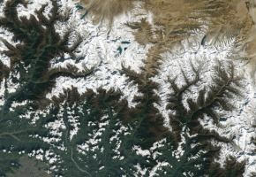
Soil conditions significantly increase rainfall in world’s megastorm hotspots

The new study led by the UK Centre for Ecology & Hydrology (UKCEH) has shown that a large contrast in soil moisture levels over a range of hundreds of kilometres results in atmospheric changes that increase rainfall area and amount in several megastorm hotspots globally. This increase ranges from 10 to 30% depending on the region and size of the storm.
Lead author Dr Emma Barton, a meteorologist at UKCEH, said: “Mesoscale convective systems are some of the most intense thunderstorms on the planet, and are increasing in severity due to climate change. Rising temperatures could increase the contrast between wet and dry areas of soils, further intensifying thunderstorms in already severely impacted regions.”
The new study involved a detailed analysis of 20 years of satellite data relating to storm activity and soil moisture conditions in West Africa, southern Africa, India, South America, as well as computer modelling.
The researchers found surface conditions that influence rainfall can be observed two to five days before a storm hits, which will allow advance warning of potential flash flooding.
The study authors explain that greater contrast in moisture between wetter and drier areas over a large distance results in a greater contrast in air temperatures, leading to stronger shifts in wind direction and/or speed as you go higher up in the atmosphere. This turbulence helps storms grow, producing more rainfall over a larger area.
In addition to their analysis in West and southern Africa, India and South America, the researchers observed the same connection between soil moisture contrasts and wind circulations in China, Australia and the US Great Plains. So while there were insufficient storm data to carry out a full analysis, they are confident that soil moisture contrasts are also exacerbating rainfall in other regions affected by mesoscale convective systems.
Source: UK Centre for Ecology & Hydrology
Image: kellogggarden.com